Interpretation
-
- The layer is deposited to level the area for the construction of a pavement and is probably contemporaneous to the construction of the casale.
-
- Monica Hellstrom
- 25-6-2008
Stratigraphic Relationships
-
Cuts
VM_7014 -
Covers
VM_7028 -
Covers
VM_7030 -
Covers
VM_7031 -
Covers
VM_7033 -
Covers
VM_7035 -
Covers
VM_7037 -
Covers
VM_7039 -
Covers
VM_7041 -
Covers
VM_7047 -
Covers
VM_7062 -
Covers
VM_7064 -
Covers
VM_7066 -
Covers
VM_7068 -
Covers
VM_7077 -
Covers
VM_7079 -
Covers
VM_7084 -
Covers
VM_7097 -
Covers
VM_7100 -
Covers
VM_7117 -
Covers
VM_7121 -
Covers
VM_7137 -
Covers
VM_7143 -
Covers
VM_7146 -
Covers
VM_7148 -
Covers
VM_7150 -
Covers
VM_7151 -
Covers
VM_7152 -
Covers
VM_7155 -
Covers
VM_7156 -
Covers
VM_7159 -
Covers
VM_7160 -
Covers
VM_7164 -
Covers
VM_7183 -
Covers
VM_7184 - Edit
-
Site Photo
- No records attached.
Description
- composition, color, compaction
- pick, trowel
- sandy soil with small stones
- brown
- loose-medium
- ok
- artificial
- stones of small dimensions
- sandy soil
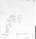
- Fill layer consisting of sandy brown soil mixed with small stones. It covers most of the north part of the trench east of wall 7007. The layer appears level at the surface but thickness varies according to the levels of the contexts underneath it.
- The layer is very thin in the east and south parts of the trench. Parts of the layer have been bobcatted away and thickness is not determinable in all areas.
- poor
Ceramic Inventory
- 500 AD - 699 AD
There are no results for this record
