Interpretation
-
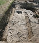
- This seems to be a shallow robber trench for the removal of a wall that seems to lack any significant foundation system.
-
- Megan McNamee
- 27-6-2008
-
- In the section it is clear that the robber trench was, initially much deeper, but its highest limits were removed with the bobcat as is clear in the W LOE
-
- Megan McNamee
- 16-7-2008
Stratigraphic Relationships
- No Linked Records
Description
- form
- trowel and pick
- N-S: 0.70; E-W: 5.62; depth: 0.13
- good
- artificial
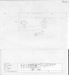
- A shallow rectangular cut running E-W in western area of the trench (rm I, bldg I). Its highly regular/linear north edge is preserved and clear in the pavement it cuts (4017). This is also true of its southern edge in the eastern part of the cut. As towards the west, the southern edge is far less distinct and cuts through a series of contexts and also seems to join with other cuts so that near the W LOE, the southern side of the cut takes on a circular shape. The cut is quite shallow, bottoming on a pavement in the east and a compact dark purple-red layer of earth with brick and mortar components.
- The limits of the context were extremely clear where 4017 was cut in areas where this pavement still exists. In other areas, the limits were less clear and the context was over-excavated in its SE corner. It was clear however, in the section, that the trench had more consistent dimensions.
- high
Ceramic Inventory
There are no results for this record
Basic Information
- Oblong E-W oriented cut in _4017_
Plan
Record Details
-
- Lisa Fentress
-
- Caroline Goodson
- 27-6-2008
- Megan McNamee
- 24-6-2008


